Kifisou Spring (Agia Eleousa) Polidrosos.
-

In 1908 a sculptured statuette was found in excavations carried out in the area. Α work of the 3rd century BC which is exhibited at the National Archaeological Museum (No. 2772) and is known as the 'child with the goose'. It is believed to have been crafted in an Athenian workshop by the son of Praxiteles, Kifissodotos and constructed out of Pentelic marble. (Source: LIS of Polydrosos). -
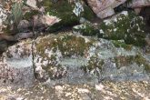
This construction was located beside the spring. Most likely to be ancient royal family seats. -
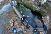
Just outside the entrance of Polydroso spring. -

Root systems which have developed from trees outside the spring. -

The well is one of the most beautiful parts of the underwater cave. -
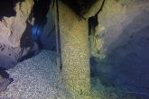
The drill pipe. -
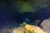
Cave divers follow the upward route of the cave. -
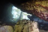
The only opening from which the divers enter and exit, as seen from within the cave. -
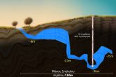
Mapping of Polidrosos spring. -

The surrounding space around Polydrosos Spring is always clean and well taken care of, due to the efforts of the volunteers of Women of Polydrosos organisation. They are also responsible for the construcion of the beautiful wooden bridge and the pedestrian benches on the spot. ( Club Estia ) -
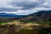
Aerial photo of Polidrosos. -

Video from Polidrosos cave.
Spring of Kifissos. (Agia Eleousa). Polydrosos.
The beautiful village of Polydrosos is built on the northern foot of mount Parnassos at an altitude of 380 meters. According to the ancient scripts of Pausanias the original name of the area was Lilea, a city which was ruined in 480 BC from Xerxes army during the second Persian campaign against Ancient Greece. The area in modern times was named Souvala. In Slavic it means a hollow with surrounding mountains, in the Turkish language it is interpreted as a location with a lot of water. All of which are interpretations that fit perfectly with the region’s scenery. Ιn 1928 with a government decree of the New Hellenic state, the name changed from Souvala to Polydrosos. The village was originally at a higher altitude than its present location but was destroyed by a powerful earthquake in 1870. Subsequently its residents were forced to descend to the plains and create Polydrosos in its present form. Very close to the village, about 1.5 km northwest, lies the spring of Kifissos or else of Agia Eleousa. Exactly above the spring we find remnants of an ancient sanctuary devoted to the worship of Apollo. In 1908 a sculptured statuette was found in excavations carried out in the area. It is a work of the 3rd century BC, which is exhibited at the National Archaeological Museum (No. 2772) and is known as “The Child with the Goose”. It is believed to have been crafted in an Athenian workshop by the son of Praxiteles, Kifissodotos and made of Pentelic marble. The discovery of the inscription leads to the conclusion that the sculpture was an appeal to the god Kifissos. Originally handed
over by an officer of the state police P.Dalona to the National Library and then to the National Archaeological Museum. A beautiful location surrounds the springs with ancient and Byzantine buildings, water and plane trees, whilst in close proximity to the ruins of the Byzantine church of Agia Eleousa. In the 1980s, the first drilling was carried out for the exploitation of the natural water resources to supply the inhabitants of Polydroso and for irrigation use.
Information about the cave.
The entrance of the spring has a south-eastern direction. The underwater explorer enters an opening with a width of 1 meter and a height of 80 cm. After the diver submerges for 2.5 to 3 meters he continues by passing through a narrow point with a height of 70 cm. Just a few meters from the entrance of the cave, we find an abundance of roots resembling huge beards, from trees just above the big hall. At this exact location above, one finds the only air pocket existing in the entire cave. Progressing further, the diver will soon reach the passage of 1.70 meters in diameter and 90 cm in height. This first well reaches a depth of 25 meters. Passing through it, the diver enters the central part of the cave which is of particular interest. There is a second well, at its shallowest point is 25 meters with a diameter of 2.90 meters and a maximum depth of 34 meters. Following this we see the two drill pipes at a depth of 36 to 37 meters (One tube is now inactive because it no longer covers the increasing needs of the population). If the diver is lucky enough and the pump is in operation, a characteristic loud sound can be heard. The big borehole is 70 centimeters in diameter and it supplies half of the Polydroso population with water. Further progression into the cave, the diver will climb an uphill slope where he will reach an open plateau at a depth of 20 meters. On the left there is a blunt point where the cave line ends. The whole route from the entrance up to this point reaches approximately 180 meters. Making a small ¨Jump¨ we continue until we find a very narrow circular passage with a diameter of 0.50 cm and a length of about 15 meters. Because of the small dimensions, the diver did not try to penetrate further, it was obvious it would be impossible to turn around and exit. Upon completion of this venture, begins the journey back to the spring entrance, leaving behind a cave with such a pristine visibility. On the way back however, the scenery changes dramatically. Most of the roof contains of clay and other sediments composed out of soft material. The bubbles from the cave divers on the way in, a phenomenon known as percolation, result in dislodging the silt from the roof, thus creating virtually zero visibility conditions in many parts of the cave on the way back. The importance of a well laid out cave line is now crucial, since the divers rely solely on it to safely exit. Finally, the water temperature during the entire months of the year is close to 10 degrees Celsius. This cave amongst many others in Greece had been explored several years earlier by the cave divers Mr. Kompiliris Dimitris and Mr. Spinos Yiannis. Over the course of three months from October to December of 2017 the Grafas Diving Team successfully planned, organized and completed a series of dives at this location with the purpose of filming the cave. Team members such as Lefteris Koutalas, Stelios Stamatakis, Errikos Kranidiotis and Giannis Liardakis completed several dives penetrating the entire length of the cave to appreciate its beauty and tο enjoy cave diving.

